
Key Highlights
- Rain expected across New Jersey with heaviest downpours Saturday evening.
- Snow squall threat increases on Sunday with wind gusts up to 45 mph possible.
- Isolated snow showers likely between 7 and 11 p.m. Sunday, but no significant accumulations expected.
- Temperatures will drop into the upper 30s to low 40s on Sunday morning as cold air moves in behind the first cold front.
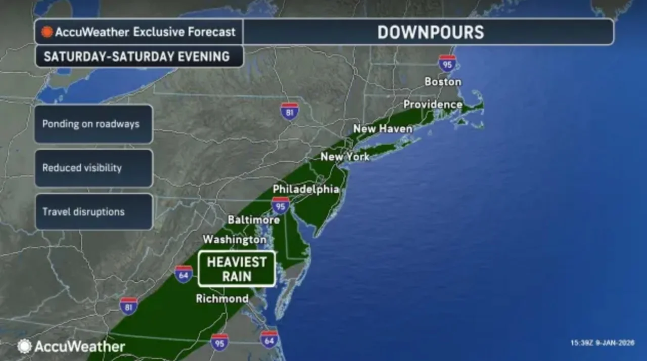
Weather Forecast for New Jersey: Rain and Potential Snow
A rain-soaked start to the weekend is anticipated across New Jersey, with the heaviest downpours expected Saturday evening. As per AccuWeather.com, rain will continue through tonight before a cold front passes early Sunday morning.
Heavy Rain Expected Tonight
The National Weather Service predicts that the southern portions of New Jersey could see up to 1.5 inches of rainfall this evening, while most other areas should receive around an inch. The northwest parts may only experience half to three-quarters of an inch. Heavy rain is anticipated through much of Saturday in the southern half of the state with totals reaching up to 1.5 inches.
Wind Gusts and Snow Squall Threat
Once the rain eases between 6 and 9 a.m. Sunday, conditions will remain cloudy and foggy until another cold front moves in late Sunday morning into early afternoon. Temperatures are expected to dip into the upper 30s to low 40s that morning as colder air flows in behind the first front.
A secondary cold front is forecasted for late Sunday afternoon, bringing with it both rain and snow showers.
Isolated snow showers will be possible mainly between 7 and 11 p.m., according to the National Weather Service. However, snow accumulations are not expected in New Jersey due to the brief nature of these events. Wind gusts of up to 25 to 35 mph by sunset on Sunday afternoon will pose a challenge for drivers and outdoor activities.
Weather Outlook for the Coming Days
Monday’s forecast calls for mainly clear skies with temperatures in the upper 30s to low 40s, accompanied by gradually diminishing winds. Tuesday will be milder with above-normal temperatures and mainly clear to partly cloudy skies, offering a slight chance of rain showers. By Wednesday, temperatures are expected to remain above normal with partly cloudy skies and a slight possibility of rain showers as another cold front approaches from the west.
Forecasters are also tracking the potential for a coastal storm that could bring snow to New Jersey late next week or veer out to sea.
AccuWeather.com reports that some models suggest significant winter storms while others indicate the system will remain offshore, adding an element of uncertainty to future weather events in the region.
The Advance Local Express Desk uses AI tools to assist in producing content, which is reviewed and edited by staff. As a reminder, all dates, numbers, names, and quotes are copied exactly as stated in the original article to ensure accuracy.