
Key Highlights
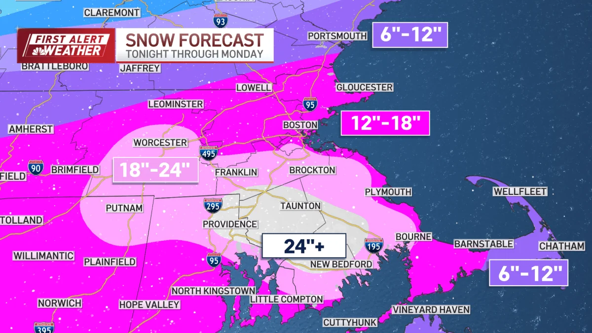
- Massachusetts could see more than 2 feet of snow in some areas.
- Travel bans are in place for the South Coast and Cape Cod.
- Crews will not venture out to repair power lines due to hazardous conditions.
- Winds are expected to peak at 60 to 70 mph along the coast, causing coastal flooding concerns.
The Blizzard’s Grip on Massachusetts
Massachusetts is bracing for a major snowstorm that could dump more than two feet of snow in some southeastern areas. Governor Maura Healey has issued travel bans to the South Coast and Cape Cod, acknowledging the severity of the situation.
The forecast suggests intense snowfall rates and poor visibility will continue through midday before gradually easing into the afternoon and evening. The storm’s criteria have been met in multiple communities including Boston and Beverly, with a high probability that the blizzard will persist until 8 p.m.
Wind Gusts and Coastal Flooding
Winds are the primary concern through the afternoon, surging to speeds of 60 to 70 mph along the coast from Cape Ann to the Islands. Away from the coast, gusts could still peak at 45 to 55 mph, including Worcester. These conditions pose a significant threat to travel and property.
The potential for coastal flooding remains a critical issue.
While minor to moderate flooding is expected, the 3 a.m. high tide was fortunately ahead of the worst of the storm, with this afternoon’s high tide running about a foot lower than anticipated. However, Tuesday morning will still experience high tides, though the winds will be blowing from land, reducing coastal risks.
Impact on Power and Infrastructure
The greatest concern for flooding remains in the mid-Cape and both Martha’s Vineyard and Nantucket. Meanwhile, power outages are a significant threat as crews will not venture out to repair lines due to hazardous conditions. Reports indicate hundreds of thousands were without power when morning arrived.
Despite dodging a major coastal flood, residents must remain vigilant.
The snowfall jackpot is centered in Bristol County, with big swaths of 18 to 24 inches predicted, and some spots eclipsing two feet. Thundersnow and lightning remain dangerous threats during the storm’s height into early afternoon.
The blizzard’s impact on travel, schools, and work will be ongoing, as cleanup efforts begin in earnest after this intense weather system passes through. The community must prepare for extended recovery times post-storm, with significant challenges ahead for those in the affected areas.